Issue 7: Summer 2012

Issue 7: Summer 2012

Regional planners hope to make more of the Bay Area like San Francisco — walkable, BARTable and energy efficient. But “smart growth” is facing resistance from cities, and financial pressure from the cash-strapped state.

Don't miss out on our newest articles, episodes and events!
Sign up for our newsletter

smartgrowth-westoakland.jpg

Cities resist regional plan to limit sprawl

A high-profile effort to focus new Bay Area housing into energy-efficient transit villages is seen as unworkable even as it makes its public debut this summer, say urban planners, because regional government lacks the authority to make cities build dense urban neighborhoods. The three-decade Plan Bay Area, unveiled in May, is the product of more than two years of research on the region’s demographics, economy, transportation and architecture. Proponents say “smart growth” could be the future of the Bay Area — if regional agencies had either the legal tools to enforce the grand vision or enough money to make it worthwhile for cities to participate.

Don't miss out on our newest articles, episodes and events!
Sign up for our newsletter

Why smart growth?

Sprawl is commonplace in the Bay Area — from places like Antioch and Brentwood on the outskirts of Contra Costa County to parts of Santa Clara and Sonoma counties. The pattern emerges from an all-too-familiar suburban formula that for decades earned developers high profits: perfectly manicured lawns, streets that meander around small neighborhood parks and cul-de-sacs at the end of nearly every block. Mixed use is forbidden — businesses are clustered into shopping malls a car trip away. Though the Bay Area started out on a European-style city grid in the era of the horse and buggy, the neighborhoods developed after World War II, after the rise of the automobile industry and interstate highway system, became the American dream.

Don't miss out on our newest articles, episodes and events!
Sign up for our newsletter

528750_10150679720513369_220527809_n.jpeg

Officials say planning for regional smart growth prevents ‘a world of hurt’

The leaders of Bay Area planning agencies are struggling to persuade local governments and community groups that joint planning will make the region more socially, economically and environmentally healthy. Dealing with sprawl, the focus of the summer print edition of the Public Press, was front and center on Friday’s edition of “Forum,” the daily public-affairs talk show on KQED Radio.

Don't miss out on our newest articles, episodes and events!
Sign up for our newsletter

hammock_web.jpg

Can San Francisco add 150,000 more people?

As the Bay Area struggles to meet sustainability goals, double-digit population growth presents a clear challenge to reducing the region’s ecological footprint. Residents must use resources more efficiently to counteract the addition of more than a million new residents. In many ways, it mirrors a challenge the planet is facing. Can population growth in San Francisco and the Bay Area be sustainable?

Don't miss out on our newest articles, episodes and events!
Sign up for our newsletter

occupysaltworks_web.jpg

Tea partiers and Occupiers make strange bedfellows opposing sprawl control

So far, Plan Bay Area — an ambitious regional blueprint for dense urban communities convenient for walking and public transit — seems to have more strident critics than defenders. Some libertarians, liberal Democrats, environmentalists, professional urban planners and anti-capitalist Occupiers have all found issue with parts of the plan, and the way its authors have sought public opinion.

Don't miss out on our newest articles, episodes and events!
Sign up for our newsletter

b01-06_where_we_live_now_small_size.jpg

Map: Where we live now — 2010 household density and priority development areas

Part of the challenge facing regional planners, who wrote the 30-year Plan Bay Area, is that it is hard to predict future population growth. The current list of more than 200 potential priority development areas in the plan tracks established high-density zones closely, indicating that the Association of Bay Area Governments, the Metropolitan Transportation Commission and other regional agencies want to fill in developments in areas that are already highly urbanized or near mass transit lines, instead of in undeveloped or underdeveloped suburban settings. This map helps readers of the Public Press’s summer edition special project, Growing Smarter: Planning for a Bay Area of 9 Million, understand these trends.

Don't miss out on our newest articles, episodes and events!
Sign up for our newsletter

hammock_popgrwtraffic_002c.jpg

Ever-changing population predictions frustrate Bay Area smart-growth planning

State and regional planning agencies have produced differing predictions of how many people will migrate to the Bay Area in coming decades. The disagreement is frustrating efforts to forge a consensus on how many hundreds of thousands of new homes to build across the region, and where. In May, the California Department of Finance took a fresh look at economic forecasts and officially backed away from its prediction that 9.5 million people would live in the Bay Area in 2040. The state now says it is likely to be closer to 8.4 million. But the Association of Bay Area Governments pegged the population for the same 2040 target date at a robust 9.3 million. The agency is charged with developing Plan Bay Area, an ambitious agenda to reshape the sprawling region by building 660,000 new homes in the urban image of walkable, transit-friendly San Francisco.

Don't miss out on our newest articles, episodes and events!
Sign up for our newsletter

img_1424.jpg

With redevelopment’s end, Bay Area cities scramble to keep grand plans alive

Oakland’s Auto Row renaissance may have to work on a smaller scale
Since 2000, city officials have had big plans for Auto Row. They called it the Broadway-Valdez project, a 96-acre development that included a strip of housing and restaurants next to the 19th Street BART station, the Valdez Triangle.Planners said the effort, if fully funded, would be Oakland’s best bet to revive its sagging retail sector. But the project’s prospects have dimmed since California killed redevelopment funds as a way of backfilling the state budget deficit.

Don't miss out on our newest articles, episodes and events!
Sign up for our newsletter

b01-06_the_bays_50-year_boom_small_size.jpg

Map: The bay’s 50-year boom — population growth, 1960-2010

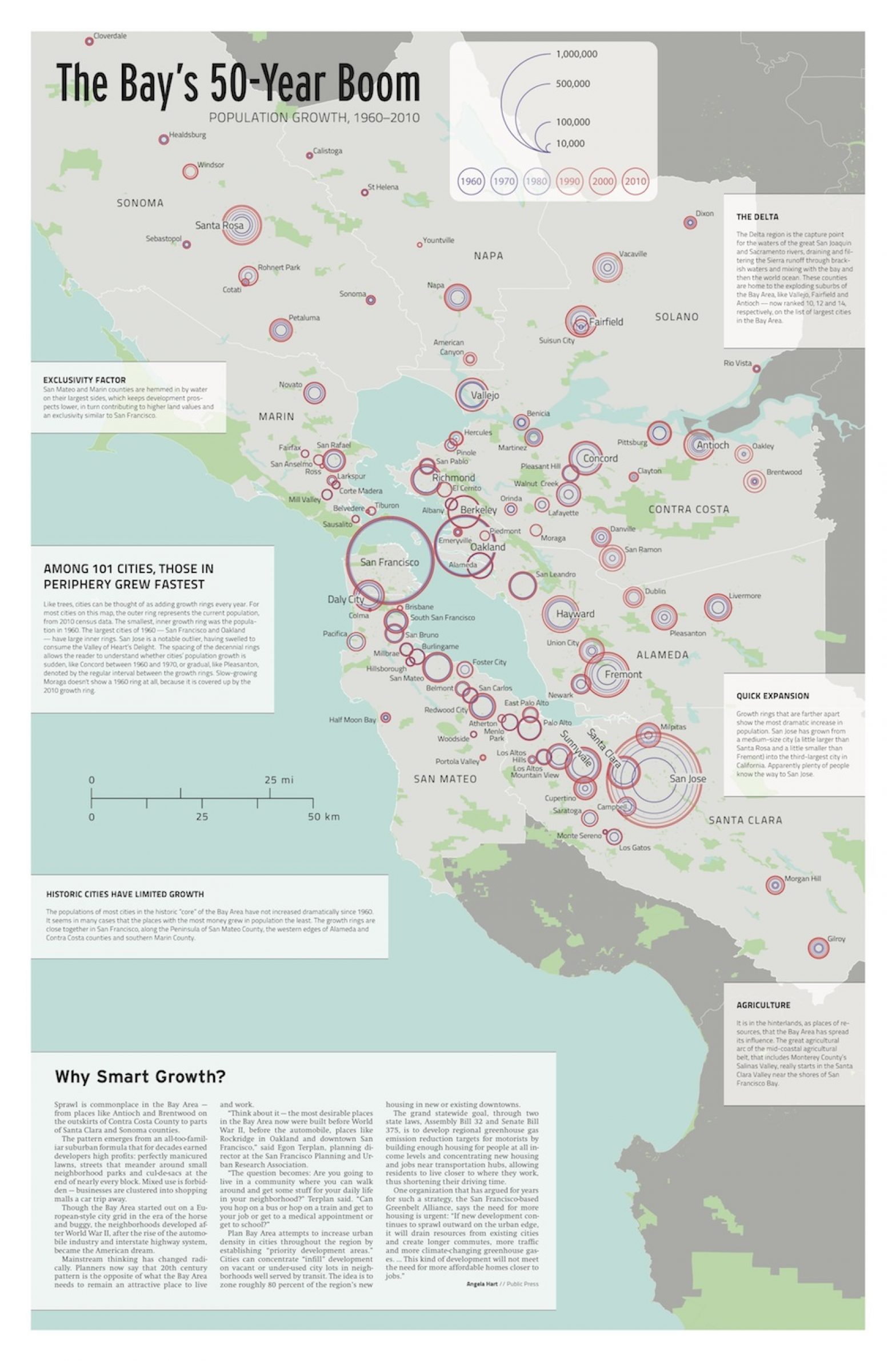
Among 101 cities, those in periphery grew fastest
Like trees, cities can be thought of as adding growth rings every year. For most cities on this map, the outer ring represents the current population, from 2010 census data. The smallest, inner growth ring was the population in 1960. The largest cities of 1960 — San Francisco and Oakland – have larger inner rings. San Jose is a notable outlier, having swelled to consume the Valley of Heart’s Delight. The spacing of the decennial rings allows the reader to understand whether cities’ population growth is sudden, like Concord between 1960 and 1970, or gradual, like Pleasanton, denoted by the regular interval between the growth rings. Slow-growing Moraga doesn’t show a 1960 ring at all, because it is covered up by the 2010 growth ring.

Don't miss out on our newest articles, episodes and events!
Sign up for our newsletter

Marin cities rebel against regional planning

Corte Madera, population 9,300, kicked off a fierce debate in Marin over housing mandates earlier this year when the town council voted to become the first member to secede from the Association of Bay Area Governments. At the time, the nine-county planning agency (until then, made up of representatives of every Bay Area city) was launching a big regional housing-growth initiative called Plan Bay Area. Now, several local groups across the Bay Area are questioning the value of the regional plan, saying it will sacrifice local control.

Don't miss out on our newest articles, episodes and events!
Sign up for our newsletter

hammock_popgrwtraffic_001b.jpg

Rising gas prices exacerbated foreclosure crisis, researchers find

Spiking gas prices in recent years were likely a contributing factor to foreclosures in newly built outlying housing developments in the Bay Area, researchers say, suggesting that sprawl may be bad for the region’s economic stability. Two recent studies found links between gas prices and foreclosure rates across California and other parts of the nation. The highest concentrations of Bay Area foreclosures were in eastern Contra Costa and parts of Solano and Sonoma counties. The areas with the lowest foreclosure rates were in the urban corridors of Oakland, San Francisco and parts of San Mateo and Santa Clara counties — areas most accessible by public transit.

Don't miss out on our newest articles, episodes and events!
Sign up for our newsletter

kim_7544.jpg

As Mayor, Kim Would Try to Expand Inclusionary Housing Citywide

District 6 Supervisor Jane Kim represents the city’s wealthiest and poorest ZIP codes. She has focused much of her political energy on inclusionary housing — programs mandating a percentage of apartments in new developments be set aside at below-market rates — and set a new standard by securing higher-than-normal affordability ratios on several mega-projects. On homelessness, she says that if elected mayor, she would treat it more like a public health crisis than an economic problem. Second in a series analyzing the mayoral candidates’ records and pledges on housing and homelessness.

Don't miss out on our newest articles, episodes and events!
Sign up for our newsletter

cappst.jpg

Rent Control Boosters and Bashers Both Base Claims on Incomplete Research

As Californians battle this fall over a ballot measure to allow cities much wider leeway to impose all sorts of rent control, both sides of the debate throw around citations to academic papers, economic studies and seemingly compelling statistics. But a review of the available research shows that both sides are wrong.

Don't miss out on our newest articles, episodes and events!
Sign up for our newsletter