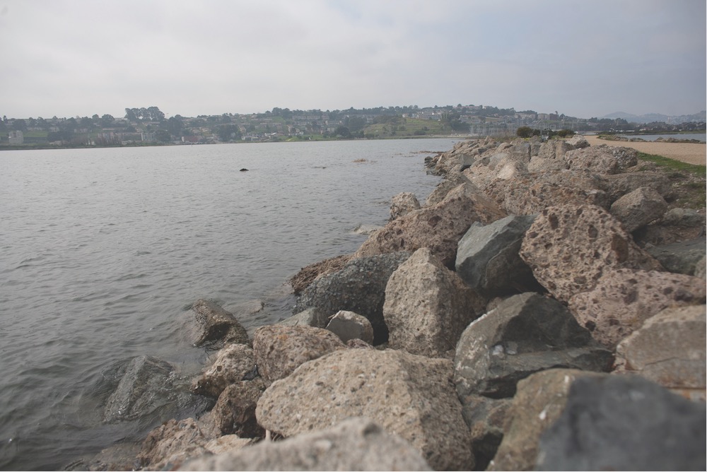
Like every body of water that opens onto a global ocean, San Francisco Bay is virtually guaranteed to rise several feet in coming decades, climate scientists say. But that has not deterred real estate developers from proposing and building billions of dollars worth of new homes and offices in bayfront areas that current climate change predictions show could flood by century’s end.
Land-use records and environmental applications reveal that the building boom, fueled by a white-hot tech economy, is moving too fast for regulators to keep pace. Most cities and regional agencies have not yet adopted tools to address flooding in areas where thousands of acres are threatened by sea level rise.
Developers say they have engineering and financial solutions to deal with any reasonable future flooding risk. But critics, including climate scientists, urban planners and environmental activists, say the current wave of construction might leave taxpayers on the hook for enormously expensive emergency protections and repairs.
Researchers studying climate change predict that the rise in ocean levels will accelerate later this century as the atmosphere heats the ocean and melts glaciers. Many of their models show that by 2100, occasional flooding could reach as high as 8 feet above current high tide, in the event of a severe coastal storm.
Even the scenario widely considered “most likely” — 3 feet of permanent rise — would put thousands of acres of the current shoreline underwater.
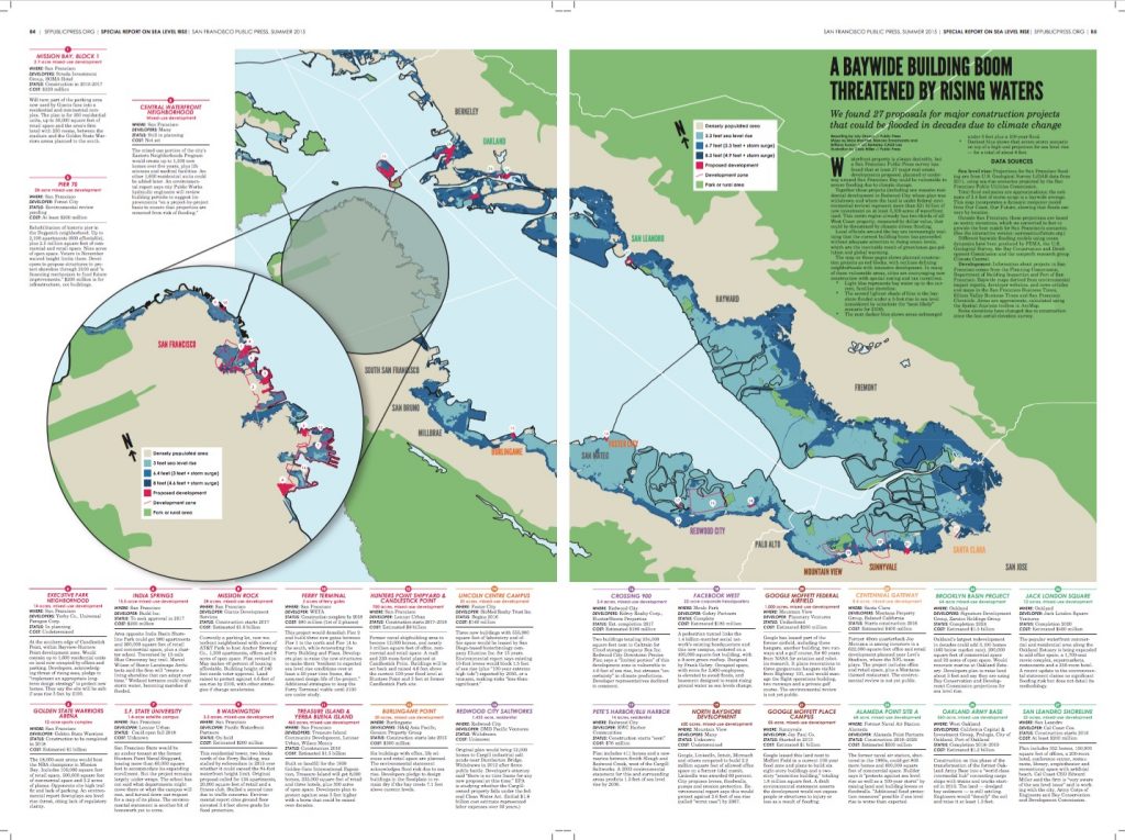
Developers are planning or currently building at least 27 major commercial and residential complexes around the bay on land lower than 8 feet above high tide, as estimated by recent aerial surveys. And more than a dozen Bay Area cities continue to issue permits for plans that address future flood risks vaguely, if at all.
[See also: interactive map.]
Google, Microsoft, LinkedIn and Facebook are among the marquee corporate names driving the bayfront explosion. Some cities are even courting companies to build near sea level, often on landfill created in the mid-20th century in former salt marshes. Much of that land could return to the sea, unless cities erect seawalls, levees and other monumental edifices.
In many areas new development includes desperately needed housing. Projects now in the pipeline in San Francisco would add 25,000 new apartments. On Treasure Island alone, developers are ready to break ground on a forest of residential towers that could house 12,000 people, and at Mission Rock and Pier 70, developers have pledged to build more affordable apartments than the city requires.
Public Costs
Corporate and government data show that the highest-profile building projects on the shorelines of San Francisco, Silicon Valley and the East Bay will cost more than $21 billion to build, excluding the value of the land underneath them.
That does not account for the likely public cost, coming within decades, of protecting these settlements with dikes, levees and artificial wetlands — or for the economic toll of abandoning development in designated buffer zones as waves rise.
A few local governments, including Mountain View, are beginning to spend money on sea level rise infrastructure projects that can protect waterfront business districts.
And San Francisco is in its second year of interdepartmental planning to address sea rise. But the city has yet to update its flood plain ordinance or planning and building codes to address increasing flood risk on the waterfront.
The San Francisco Public Utilities Commission has updated its flood maps, which guide public works investments, but other agencies do not impose those guidelines on private property.
Mayor Ed Lee and the Board of Supervisors last year resisted a call from the chair of the city’s civil grand jury to stop approving new shoreline development until stricter building rules are passed. Officials said that changes to city codes might be necessary, though until now state environmental laws and reviews have been sufficient.
Official maps upon which the city’s 2008 flood ordinance is based do not account for future sea rise. Developers say this means the city lacks the legal grounds to prevent building there.
In the past five years, San Francisco land-use agencies have approved residential, entertainment, retail, medical and office projects on nearly 50 waterfront parcels that are less than 8 feet above sea level. Major projects are somewhere in the approval process for Treasure Island and in parts of South of Market, Pier 70, Candlestick Point and Hunters Point.
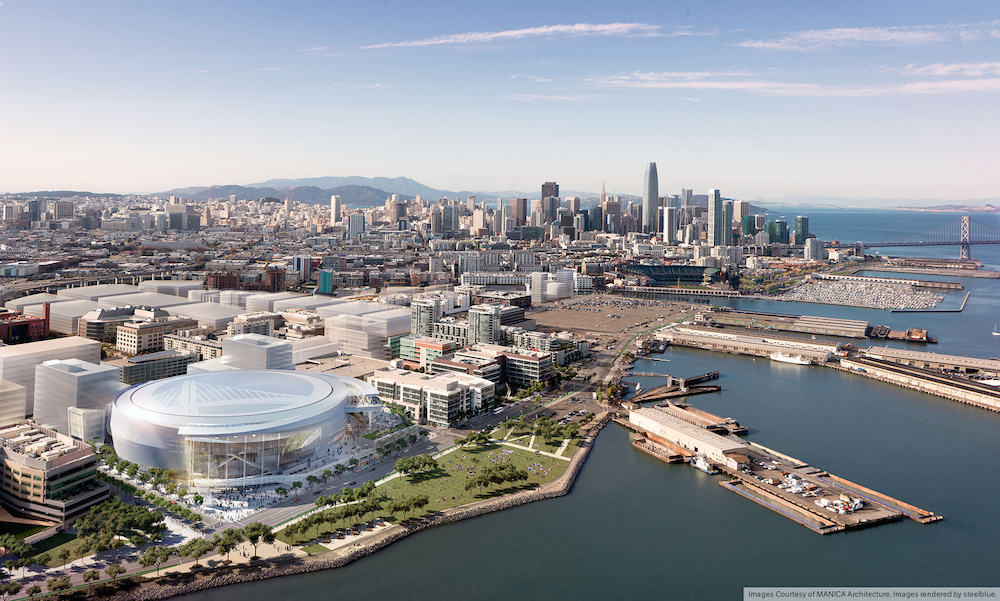
The most contentious is the Golden State Warriors’ $1 billion plan for a mixed-use facility in the Mission Bay neighborhood south of downtown. Opponents of the project, centered around an arena for the 2015 NBA champions, have focused on how it would affect traffic and bay views. But the basketball team’s engineers admit in an application for environmental review that the site could under some scenarios temporarily flood “to depths between 2 and 4 feet” by the year 2100.
Team engineers express confidence that they can design the buildings to resist storm surges by raising entrances, waterproofing basements, installing floodgates in the garage and judiciously deploying sandbags. The Warriors are expected to present the proposal to the Planning Commission this year before the scheduled release of a city-sponsored report showing Mission Bay’s vulnerability to sea rise.
Also at potential risk are hundreds of millions of dollars worth of facilities that opened this year in other parts of Mission Bay, where many streets and sidewalks are less than 10 feet above the bay’s current level. That includes University of California, San Francisco, Benioff Children’s Hospital and the San Francisco Emergency Services Center, where the city’s Police and Fire departments have set up new headquarters.
Some nearby projects do include plans to address sea rise. At the San Francisco Giants’ $1.6 billion Mission Rock development, which includes 1,500 apartments with views of AT&T Park, the plan is to elevate the land to accommodate 4.6 feet of sea rise, plus storm surge.
Development projects are springing up all around the southern half of the bay, from San Francisco to San Jose, and north to the Port of Oakland and the island of Alameda.
Maps created for the San Francisco Public Press by graduates of the Geography Department at the University of California, Berkeley, using published development plans and oceanographic data, show that current or proposed building projects that are at least partly in low-lying areas add up to more than 5,100 acres.
Around the Bay
Regional planning is hard, and the Bay Area is struggling to coordinate. There are efforts underway. Individual cities are planning to build expensive protections, and new organizations are aligning the responses of cities and public agencies. Some state-level responses are in the works. The challenge is that local development is governed by a patchwork of inconsistent zoning and differing interpretations of state law.
In a survey of 13 communities around the bay with the most intense waterfront development, the Public Press found that six had progressed beyond studying the threat of sea rise but none had an action plan. And only two — San Francisco and San Jose — had changed rules for any departments that oversee land use.
When asking for details about flood protection, cities typically rely heavily on developers to summarize which predictions for sea rise are as relevant. These predictions are sometimes based on shorter time frames than the period it will take to finish paying for the construction. Developers’ long-range engineering suggestions are often based on just 3 feet of permanent inundation by 2100, and do not account for storm surge.
Climate change science is still evolving, but the San Francisco Public Utilities Commission found that government and academic experts, including the National Research Council, the Intergovernmental Panel on Climate Change, the National Climate Assessment, state and regional climate agencies and independent research groups, largely agree on a matrix of predictions that endorse the 3-foot “moderate” benchmark.
None of the 13 cities surveyed requires developers to prepare for the less likely 4.6-foot scenario. The debate in local planning circles is whether to plan for the moderate outcome, or a less likely high-end one.
Several public and private science groups have posted interactive maps online in the past three years that show which areas would flood under various scenarios. But their creators say it has been hard to persuade city planners to use them to assess flood hazards.
In a 2009 report for the California Energy Commission, the Pacific Institute, an Oakland-based research group advocating for corporate environmental stewardship and social equity, estimated that property lost in the event of 4.6 feet of sea rise by 2099 would cost the Bay Area $62 billion (nearly two-thirds the cost for all of California). This inundation would require rebuilding the airports serving San Francisco and Oakland, and moving parts of interstates 101 on the Peninsula and 80 in the East Bay. It could also put 270,000 people in danger during severe floods, the report warned, and “continued development in vulnerable areas will put additional areas at risk and raise protection costs.”
Follow the Money
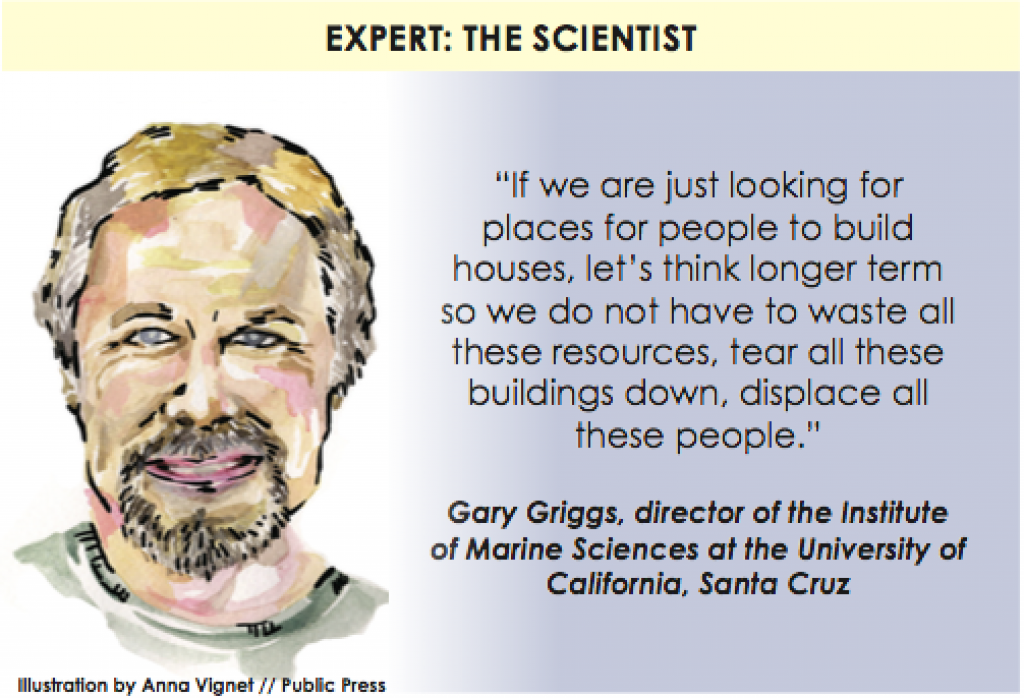
“Now is the time to look seriously at what will happen 50 or 100 years down the road,” said Gary Griggs, who directs the Institute of Marine Sciences at the University of California, Santa Cruz, and contributed to the National Research Council’s most recent report on sea level rise on the West Coast. “What is the value of making a development, housing project or mall if we know it will have to be removed later, except for some short-term temporary gains?”
Developers stand to profit handsomely from the waterfront land rush, but governments also benefit in the short run. The proposed megaprojects promise tens of millions of dollars in tax revenue. Some cities are offering developers tax credits, low-cost land and flood-control infrastructure to encourage building on their shorelines.
But there are signs of change. The Port of San Francisco in 2012 sketched a $2.7 billion concept to wrap a 10-mile-long, elevated supplemental pier around the existing Embarcadero piers, and is considering adding pumping stations and dikes.
Acting alone, cities risk pushing floodwaters into neighboring areas. In the short term, to avoid ringing the whole bay with barriers, communities could surround themselves with small levees and extend them inland up creeks. This would keep water from neighboring communities out, until it got too high.
The Bay Conservation and Development Commission, formed 50 years ago to stop developers from filling in the bay, is urging caution and trying to play a regional coordinating role. But its jurisdiction stops just 100 feet inland from the current shoreline. The commission was chartered to ensure public access to the land, not to tell developers how to build.
To address the commission’s concerns, many development plans propose a strip of grass — heralded as “parkland” or “open space” — separating buildings from the bay. This does little to protect property if seas rise even a few feet vertically, sending floodwaters thousands of feet inland.
The common roadblocks that environmentalists face nationwide in raising concern over adaptation to climate change, such as distrust of science or lobbying by the fossil fuel industry, play only a small role in Bay Area politics. Here, the obstacles involve pressure from the real estate, construction and tech businesses emphasizing short-term economic opportunity over more precautionary environmental perspectives.
Capitalizing on Uncertainty
San Francisco planning staffers say they evaluate each application for its response to the threat of sea level rise and suggest a range of adaptation strategies. According to public records, in the last five years the city has approved more than 50 projects, each worth at least $1 million, in low-lying waterfront areas. The estimated development costs of these projects exceed $4.5 billion.
A report in June 2014 from the city’s civil grand jury — a volunteer committee that examines local government — concluded that San Francisco was not moving nearly fast enough to protect public safety in the event of sea rise. David Behar, climate program director for the San Francisco Public Utilities Commission who last year headed the city’s interagency Sea Level Rise Technical Committee, said scientists’ increasing confidence in their projections and the degree of agreement among them support taking action.
This year, Mayor Ed Lee convened a new panel, the Sea Level Rise Coordinating Committee, chaired by Gil Kelley, the director of citywide planning, and Fuad Sweiss, the city engineer. He said the group would produce a “high-level assessment” of risks and vulnerabilities, and consider recommending stricter rules for private development.
Maryta Piazza, corresponding secretary of the civil grand jury, told a Board of Supervisors committee in September 2014 that the city should impose a moratorium on private developments until its codes are updated.
“If we don’t stay ahead of the trend,” Piazza said, “as we are now we’ll be forever catching up, fixing up, and ending up spending much more money in the long run.”
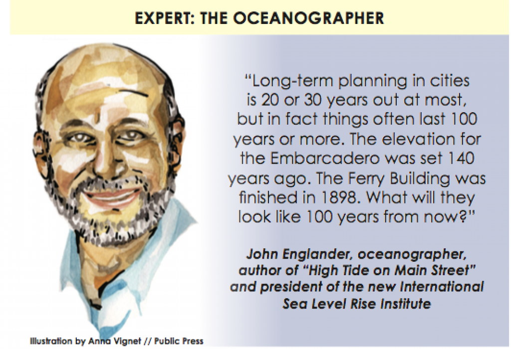
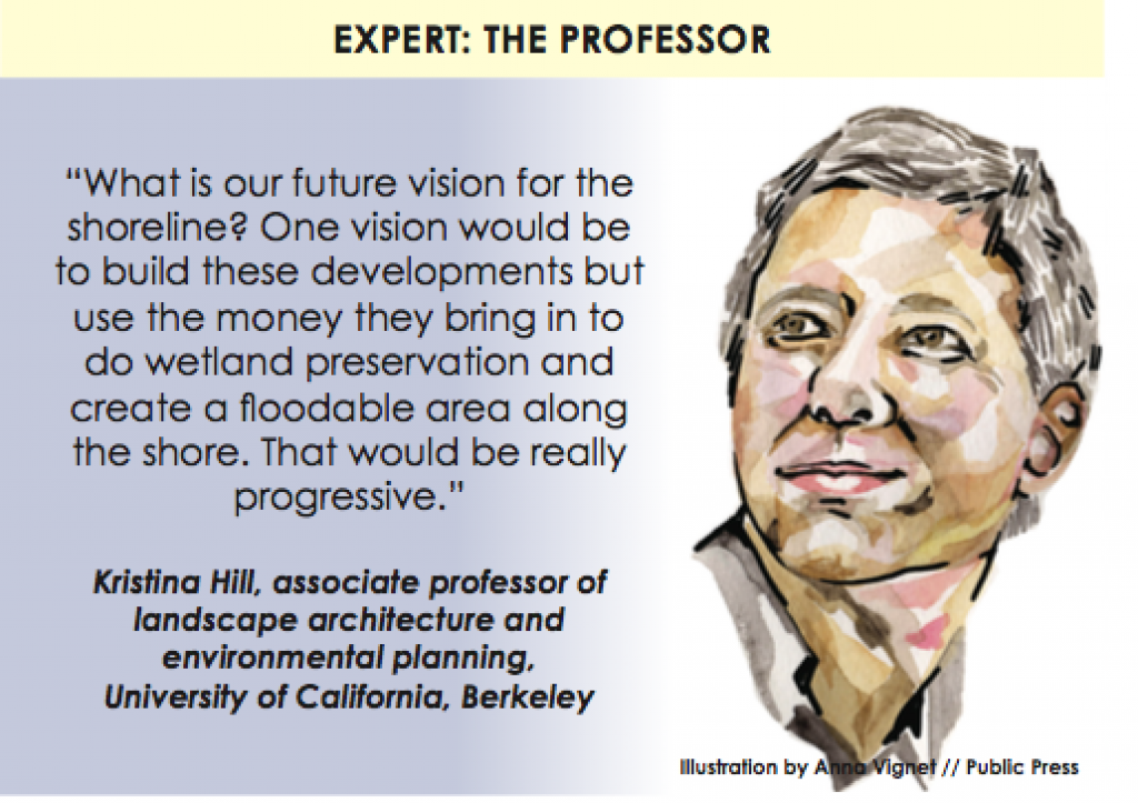
Kristina Hill, an associate professor of landscape architecture and environmental planning at UC Berkeley, said long-range planning is essential because sea level rise will be exponential.
“We are living in the last two stable decades of sea level rise,” Hill said. “Around 2045, 2050 or 2060, it’s going to get faster.”
Roger Kim, a representative of Lee’s office, said more research was needed. Lee said in a memo to the civil grand jury that requiring new buildings to withstand sea levels projected for 2050 or 2100 was unnecessary because many developments are not designed to last that long. He echoed developers, who often argue that if sea level rise becomes a problem, future generations can find engineering and financial solutions.
He added that any future regulation should be written with more nuance than determining whether a new building will flood. Rather, each development faces a different threat from storms, depending on its unique geography and the consequence if it is flooded. For example, a park is resilient to flooding in a way that an electrical substation is not. Regulations need to let planners adapt approvals to the circumstances, he said.
“It may be unwise — and expensive — to require immediate measures to adapt to wide-ranging, highly uncertain SLR projections further out in time,” Lee wrote.
Rethinking Mission Bay
On April Fools’ Day 2009, the cover story of Synapse, the student-run weekly paper at UCSF, was headlined “Mission Bay: The Underwater Campus.” With sea waters likely to threaten the health science school’s new campus within decades, the paper joked, adaptations could include a “campus housing fishing hole,” “surgical scuba gear,” and a 10-block “Third Street Ridge” cutting through Mission Bay to act as a seawall. Little did the editors know that at least one of these farcical suggestions could become reality.
In September 2014, consultants drafting a report to the city’s Public Utilities Commission and the Capital Planning Committee said sea level rise should not be addressed in a piecemeal fashion. The 303-acre neighborhood, which was an inlet of the bay before it was filled and used for a sprawling rail yard, must be rethought comprehensively. One suggestion from the consultants is to put Third Street on top of a levee that would reduce flooding risk in most of Mission Bay.
“The entire shoreline is too low to be protected, so what can we do about that?” Laura Tam, environmental director at SPUR, a Bay Area urban planning and advocacy group, asked at a City Hall hearing. “We cannot just protect individual buildings. We need something that protects the whole area in the long term.”
Tam co-authored the forthcoming report with Peter Wijsman, a consultant with the Dutch engineering firm ARCADIS, which has engineered solutions to sea rise in the Netherlands. Wijsman said options for Mission Bay ranged from “learning to live with water” to “armament” for the shoreline. Officials also discussed a “Venice-style” system allowing water to flow around flood-proof ground-level shops and building entrances. (See video.)
When UCSF began planning its new medical center in the 1980s, it stabilized the land in Mission Bay by adding more fill on top of the sand brought in from SoMa during the 19th century and debris added after the 1906 earthquake and fire.
Paul Franke, a senior planner for the medical center, said the grade was raised by 2 to 5 feet to ensure that hospital and research buildings could withstand 3 feet of sea level rise. He said that was meant to make the project last “in perpetuity.”
When the city reviewed Mission Bay’s original sitewide permits in 1998, officials generally planned for 100-year floods, those with a 1 percent chance of happening each year. They used older predictions of sea rise and less precise topographic mapping, focusing on relatively short time horizons (8 inches by 2025). But Franke said UCSF will monitor the science over the next 50 years to ensure “we were not tragically off in our predictions.”
Meanwhile, the hospital is planning more facilities even closer to the bay and recently bought a parcel east of Third Street near 16th. As an arm of the state, UCSF gets its permits from the Division of the State Architect, not the city. But San Francisco planners do have regulatory power over the Warriors arena. Developer Strada said it plans to explain in reports mandated by state law how it will safeguard the facility, whether by raising the land, permitting some flooding or building barriers.
With the Warriors’ environmental review scheduled months before the Mission Bay sea level rise report is due, and given the mayor’s unwavering support for the sports facility, it is hard to see the Planning Commission derailing the plan because of the threat of sea level rise.
Representatives of Prologis, the developer overseeing* all Mission Bay planning, did not respond to repeated calls for comment on long-term plans.
Costly Fixes
At Treasure Island, the towers approved by city officials will include 8,000 homes and 235,000 square feet of retail space. Kheay Loke, a manager with development firm Wilson Meany, says the project makes sense because the area already has roads and electricity, so developing there is more environmentally sustainable than building in the suburbs. For the company, it means not having to install new infrastructure.
For years, the property’s developers have emphasized their plans to conserve energy, maintain open spaces and build walkable neighborhoods, linked to the rest of the city by public transit, including ferries. In an interview in a downtown conference room with a view of the island, Loke said there was an easy — if “sacrilegious” — solution to sea level rise.
“Fill in the bay,” he said. “You go 50 feet out, and you build yourself a levee.”
Wilson Meany and co-developer Lennar Urban already plan to fortify existing berms around the 400-acre island to make them broad enough to build higher in the future. And they plan to raise the land, at a cost of $1.2 billion. Construction will continue through 2035.
“We can adapt and protect,” Loke said. “Sea level rise and flood protection are problems that money can solve.”
In this case, the money probably will come from the island’s future taxpayers. Treasure Island property owners will pay a special fee, called a Mello-Roos tax, to fund any future adaptation measures needed after the developers leave.
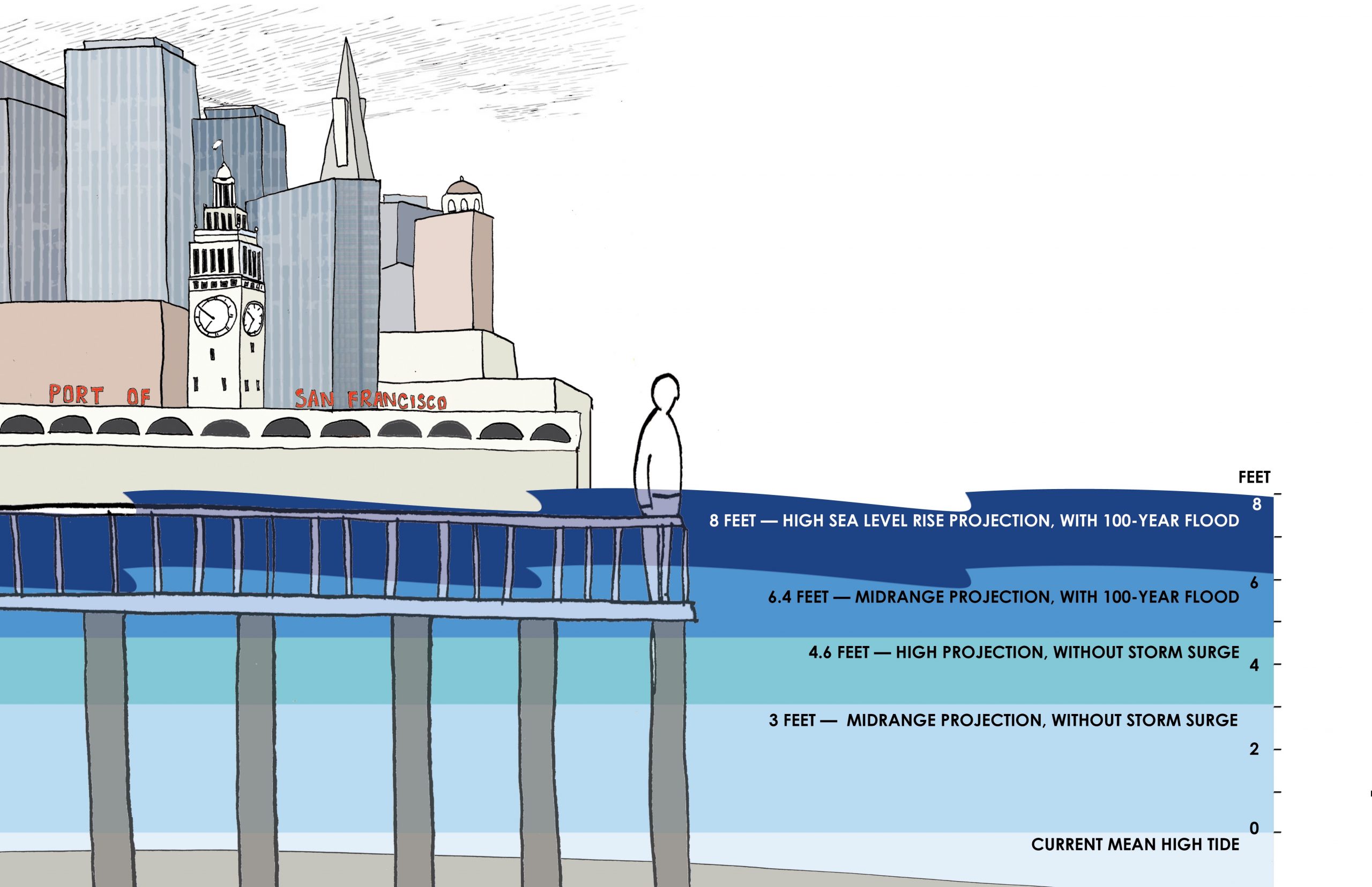
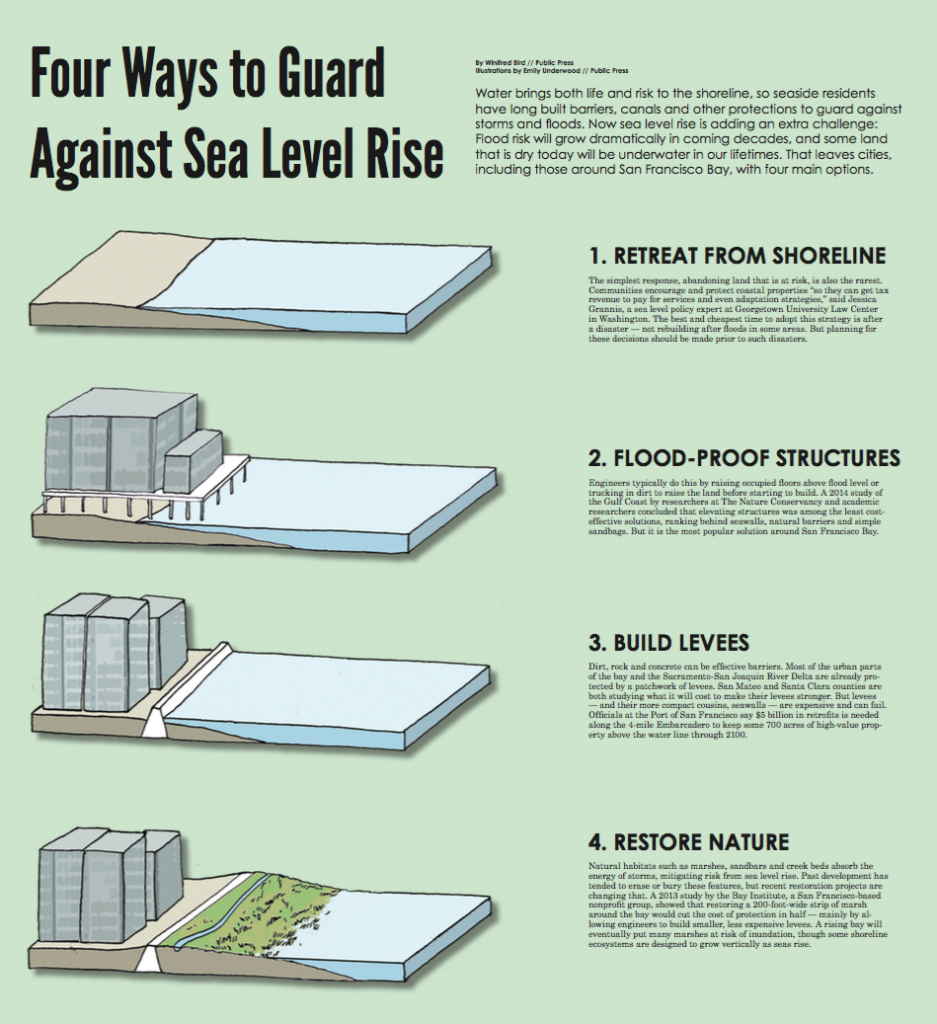
Sources: Projections from the San Francisco Public Utilities Commission, based on a 2012 National Research Council report on West Coast sea level rise. San Francisco also studies projections by the U.N.’s Intergovernmental Panel on Climate Change, the California Ocean Protection Council and the California Coastal Commission.
Illustration by Emily Underwood / San Francisco Public Press
Brad McCrea, regulatory program director at the Bay Conservation and Development Commission, said Treasure Island’s developers brought “eyes-wide-open expertise” to their planning. But he said he was skeptical of applying this kind of technology-centered approach everywhere around the bay, given that sea level rise could continue for centuries. “At the end of the day, this will be a levee-protected community,” McCrea said. “There’s no getting around that.”
McCrea said Bay Area communities should be talking about retreating from the riskiest shoreline areas. “This is not about Treasure Island, but there are some basic questions here about where is the right place to build.”
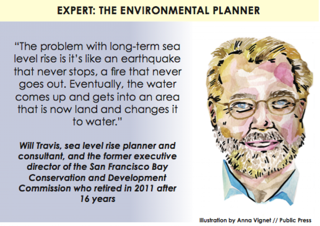
Will Travis, who headed the commission for 16 years until 2011, said the region needed a more “thoughtful, reasoned, rational and financially sound solution.
“It will buy you 50 years of time to get our heads around this notion of ‘permanent temporary’ development,” he said. “Getting developers and local governments to think half a century ahead is very hard.”
Developers are spending millions of dollars on public relations to persuade voters that they are building safe and environmentally benign projects. In November, San Francisco voters approved Proposition F — which technically exempted Pier 70, a development south of Mission Bay, from height limits, but in effect endorsed the construction of commercial space and 2,000 homes (600 affordable) on 28 waterfront acres. Our maps suggest that large portions of the former industrial area could be submerged under several feet of water by 2100 in the event of 6.4 feet of flooding (the intermediate prediction for sea rise and extreme storm surge).
After three years of public outreach, developer Forest City spent almost $3 million on the campaign, including paying $15,000 to the San Francisco Democratic Party, $10,000 to the Republican Central Committee and $25,000 the Sierra Club for mailing campaign fliers. The project won endorsements from the city’s last three mayors, all 11 current members of the Board of Supervisors and more than 50 community groups. Activists with the Sierra Club’s local chapter told a reporter last fall they never pressed the developer about sea rise.
Forest City has not yet sought environmental permits, so its specific plans are not public.
Other proposed waterfront projects that still need some approvals include the sprawling Hunters Point development that includes 1,600 homes now under construction at the old Naval Shipyard, and a commercial and residential complex rising at Candlestick Point to replace the eponymous stadium. Developers are raising the land there to keep buildings, streets and key infrastructure above the moderate estimate of the 100-year flood level — a few feet of storm surge on top of 3 feet of sea level rise.
Planners Value Flexibility
Chris Kern, a senior environmental planner for the city, said the lack of firm city codes allows easier adjustment to new scientific projections. It is sufficient that state law requires the city to assess whether new projects “expose people or structures to a significant risk of loss, injury or death involving flooding,” he said. The city interprets that to include future flooding from sea rise.
The San Francisco Public Utilities Commission’s Behar said it was common for government to test regulations by applying them to public property before forcing compliance in the private sector. Perhaps surprisingly, the real estate and development industries are not uniformly opposed to regulation. Developers say working under clear rules makes it easier and less expensive to plan. “Sea level rise adaptation should be government mandated,” said Loke, of the Wilson Meany development firm.
Piazza, the civil grand jury member, said San Francisco should halt the rapid pace of development until it adopts comprehensive policies that protect both public safety and private property. If the city takes too long, all the gaps in the waterfront skyline will have been filled in by the time the rules go into effect.
Tam, a longtime advocate for regional climate adaptation planning at SPUR, sees hope in the city’s new approach.
“Five years ago, this topic was virtually unknown,” she told John Upton, a reporter for Climate Central, a nonprofit that researches and reports on climate change. “Today, many city departments have not only participated and worked together to produce this guidance, but they are working collaboratively to develop solutions.”
Kelley, the director of citywide planning, said it was too soon to recommend new planning codes. “We need to know what the problem is before we come up with an answer,” he said. “This will lead to some discussion of what we might do.”
Silicon Valley Growth
When Google first proposed in February to build a massive new headquarters in Mountain View, it issued promotional videos and renderings showing 3.4 million square feet of office space under undulating canopies of glass and plastic.
Peter Gleick, president of the Pacific Institute, blasted the tech giant’s choice of location.
“Their property at the south end of San Francisco Bay is extremely vulnerable to projected sea-level rise,” Gleick blogged. “Google is a forward-looking company. But are they looking forward to, and planning for, the now-unavoidable impacts of climate change as they design new multibillion dollar infrastructure investments?”
Mountain View’s North Bayshore neighborhood hosts Google’s current headquarters, as well as offices for Microsoft, Intuit and other companies. The city’s plan envisions a walkable community of corporate campuses, stores, hotels, services and entertainment. Flood maps show that much of the zone could be underwater with 8 feet of combined sea rise and severe storm surge. But the plan looks only to predictions for the year 2064, when, it asserts, seas are expected to rise a maximum of 3 feet.
Mountain View has set aside more than $43 million for proposals to bolster existing levees, pump stations and tide gates, the Bay Area News Group reported in June.
In May, the City Council voted to award the majority of the developable office space to LinkedIn’s Shoreline Commons mixed-use concept, based largely on its claims that it would “preserve business diversity” — a reference to Google’s already dominant footprint in the city.
But Google has designs on several additional waterfront properties. In neighboring Sunnyvale, it took over a 60-year lease from NASA for part of the land at Moffett Federal Airfield, where the space agency had concluded it needed a buffer zone to keep rising waters out.
In Menlo Park, Facebook recently finished a new campus with a 430,000-square-foot building, featuring 9 acres of rooftop foliage, designed by Canadian architect Frank Gehry. According to recent U.S. Geological Survey data, parts of the site were below 8 feet in elevation before it was developed.
In its environmental impact report, Facebook said that although the average height of the land was 9 feet, the buildings themselves would be “raised above future flood risk.”
The environmental report also argued that Facebook was not technically obligated, under state rules, to judge environmental risk to the facilities, even though the company had taken various protective measures.
As the report put it, the purpose of state-mandated review “is to evaluate the effects of the project on the environment, not the effect of the environment on the project.”
Facebook representatives declined to speak on the record about the company’s flood plain adaptation strategies.
Charlie Knox, a principal at PlaceWorks, a firm in Berkeley that helps cities plan for sea level rise, said the main Facebook building would probably be safe from flooding through the 22nd century. “They are pretty hip and they have over-anticipated sea-level rise,” he said.
In an extreme event such a building, elevated on concrete pillars, would probably survive, though the land around it would be submerged. “People would be sitting in their offices looking at the water,” he said. “It is a model for adaptation.”
Knox said technology firms know the risks they are taking by proposing and building tens of millions of square feet of new research and development facilities.
“There is a ton of good jobs, meaningful stuff that will help medicine and human life, and it is all going up like crazy,” he said. “And it is all in a place that sea level is going to rise.”
East Bay Renewal
Large swaths of underused East Bay waterfront have been under construction for years, with some projects originally financed by redevelopment funds that the state pulled back after falling into deficit. At Oakland’s Jack London Square, the newest project includes a 1,700-seat movie theater, restaurants, supermarkets and a 250-room hotel with a marina and small beach. Developers said it faced no flood risk, though they did not address sea level rise in their 2004 environmental impact report.
But an addendum to the report released this May asserted that the company was not “required to analyze or mitigate impacts pertaining to the impact of the environment on the project.” The construction, the company explained, “is not causing sea level rise, sea level rise will occur regardless of the proposed project.”
Construction also is underway on 1 million square feet of warehouse space at the former Army base in West Oakland. Local officials laud this project as a restoration of the “working waterfront” because it will bolster a growing freight industry by connecting cargo ships with trains.
In Alameda, development is continuing on the site of a Naval Air Station that shut down in the 1990s. Currently in the works are 800 apartments and 600,000 square feet of retail space in a $500 million project by Alameda Point Partners, which proposes to raise the land and build levees in the future to keep land below sea level from flooding.
In addition to 26 current major development plans the Public Press found to be at least partly below the projected 8-foot elevation, we found a 27th that for now seems to be off the table. Starting in 2009, Arizona-based DMB Pacific Ventures sought permission from Redwood City to build 12,000 homes on 1,478 acres of bayside salt evaporation ponds owned by agricultural giant Cargill. It was withdrawn in May 2012 after a firestorm of protest from neighbors, some of whom were concerned about the environmental effects of building farther into the bay. Project attorney David Smith said there was “currently no development proposal whatsoever pending for the site,” though the project’s website said a “scaled back” plan was in the works.
The U.S. Army Corps of Engineers concluded in 2014 that the federal government had no jurisdiction over most of the Redwood City site. But the federal Environmental Protection Agency — which has spent more than $40 million to restore San Francisco Bay wetlands — announced in March that it was investigating whether the land falls under the Clean Water Act. This could be a test case for whether the EPA can include sea level rise in assessing future flood risk or limiting shoreline development.
Search for Solutions
Several regional initiatives aim to coordinate how bayfront cities cope with sea level rise. Most notable are the Resilient Shoreline Program, the San Francisco Bay Regional Coastal Hazards Resiliency Group and Our Coast, Our Future.
The state has created a $2.5 million California Climate Resilience Account to pay for planning. Legislation is also pending on a statewide database of preparedness work.
In the South Bay, a coalition of federal and state agencies including the Army Corps of Engineers, the Coastal Conservancy and the Santa Clara Water District are proposing the federal government spend $162 million for wetlands restoration and levee construction. Also in the South Bay, a regional authority is widening old levees and building new horizontal ones around San Francisquito Creek.
But creating consistent rules governing private property could be a challenge. “Regulations around climate change are in their infancy, or nonexistent,” said Behar of the San Francisco Public Utilities Commission.
Jasper Rubin, a professor of urban planning at San Francisco State University, said the common solution of raising land to raise the height of buildings fails to address the “larger systemic issues.” If one property is raised, he said, it “doesn’t mean the rest of the waterfront’s not going to get inundated.”
Kristina Hill, the UC Berkeley planning professor, said more experimentation is needed in waterfront construction techniques. But few businesses are invested in fortifying the properties they build beyond midcentury. It is hard to fund resilient architecture, Hill said, when developers “do not have a shared interest with the public about what will happen with those properties in the future.”
Some environmental and planning experts are appealing directly to the public to change sea level rise policies. The King Tides Project publishes reports on coastal erosion and flooding that occur when sun and moon align, known as king tides. These events offer a preview of sea level rise.
Project co-founder Marina Psaros started working with the Bay Conservation and Development Commission to urge cities to pass new flood zone regulations. “Our theory was we need to get heads of planning and public works directors aware, concerned, activated on climate change,” Psaros said.
Discouraged by institutional inertia, she shifted her focus to public outreach, publishing dramatic photos of high tide events on social media.
Knox, the consultant who works on adaptation planning around the bay, said that the time horizons of developers and governments are too short to deal with the effects of climate change. The waterfront will change noticeably even in a single lifetime, but sea level rise will plague coastal communities for generations.
“One of the problems we face is that we do not live very long,” Knox said. “We think, ‘I’m going to move into this house and have kids here.’ People do not care what the house will be in 200 years. But now we have to think differently.”