With your support for our Pedal-Powered News campaign on Kickstarter, we’ll have a team of newsies on bikes ready to deliver our summer print edition to destinations throughout San Francisco. What routes will they take as they zoom around the city? Very likely one of these:

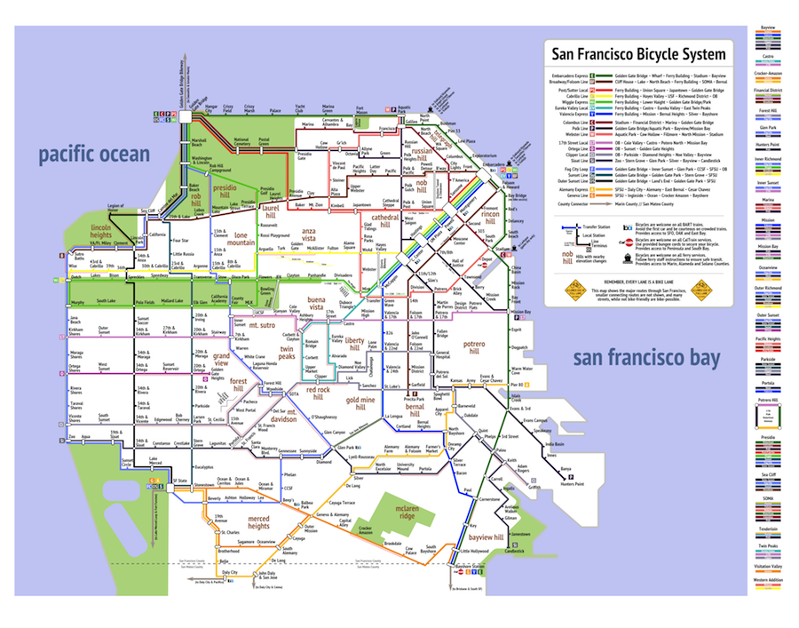
This subway-style map comes courtesy of San Francisco cyclist Mat Kladney, who submitted it to the See-Through Maps exhibition at U.C. Berkeley last year, where it was a finalist.
“As a long time cyclist, I recently realized that the mental map that exists in my mind of San Francisco is different from most (and importantly does not exist in print form),” Kladney wrote in an essay accompanying the map.
Kladney’s map answers the simple, practical question “how do I get from here to there?” But as any cyclist will tell you, the ride is often its own reward.
Kladney emailed the Public Press details about three routes he’s been enjoying lately:
1. O’Shaughnessy hill along Glen Canyon and connecting it to Laguna Honda. It is a long, slightly steep hill, but very bikable and beautiful along the whole length of the trail.
2. Polk Street, it is a little crazy and a little dangerous, but really fun and MUCH faster than street traffic. And with the northbound contra-flow bikeway, is now directly connected to Market Street.
3. Riding to Golden Gate Bridge from Arguello. You only have to ride up one hill and are awarded with the best views of the bay.
If you want one of your own, Kladney’s awesome map is available for purchase on his websitewww.sfbicyclesystem.com.
And if you haven’t already, please support our Pedal-Powered News Kickstarter campaign! Every dollar counts!