A community-funded report originally published on Spot.us
 |
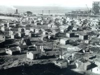
| A Depression-era Hooverville. |
San Francisco’s per capita homeless rate has long been the highest in the country. But in the past year, it has shot up 40 percent, by some measures. The increase came as foreclosures put pressure on the rental market, the budget crisis slowed aid, and the job market tightened up.
The face of the homeless population is changing, too. The newly unemployed and the working poor are finding themselves out on the street. And the lines for affordable housing grow ever longer. Some families wait years to get a Section 8 voucher, and while they wait, they sleep in their cars, on the streets, or, in an emergency shelter, that is, if they can get a bed.
In the first chapter of a two-part series on homelessness in California, Thea Chroman introduces us to a family staying at San Francisco’s Providence emergency shelter.
- Hear reporter Thea Chroman’s piece on KALW Radio (2/4/09)
Read Thea Chroman’s second piece, "Shanty Towns Rise in the Central Valley as Poverty Rates Climb".